Samples of Urban Fabric in Singapore
The maps present geospatial data samples of contemporary urban fabric. Each of the samples documents an area that covers a 10-minute walking (600m) radius around a transit station along all available pedestrian paths. The maps document three layers of data:
- The load-bearing structural elements of the buildings' ground floors
- The three-dimensional full extent of the pedestrian path network (including exterior and interior paths that are accessible to the general public)
- The three-dimensional distribution of all building entrances and business establishments with descriptive attributes.
Combined, these data layers were chosen to embody complementary morphological attributes that allow the samples of urban fabric to be compared and studied in great spatial detail. The data can be explored on web-browsers, or downloaded in PDF or SHP file formats. The data are available for download and free use, but we kindly ask all users to acknowledge the City Form Lab in publications and presentations.
Click on the images below to see the interactive map data of both areas.
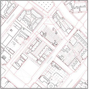
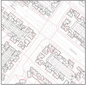
| Bugis, Singapore | Punggol, Singapore | ||
| Public pedestrian network : | 272.3km | Public pedestrian network : | 77.9km |
| Indoor public network length: | 114.1km | Indoor public network length: | 6.4 km |
| Outdoor public network : | 158.1km | Outdoor public network : | 71.5 km |
| Nr. of buildings: | 696 | Nr. of buildings: | 293 |
| Gross floor area of buildings: | 1,568,730 m2 | Gross floor area of buildings: | 2,556,840m2 |
| Nr. of entrances: | 4,952 | Nr. of entrances: | 434 |
| Nr. of businesses: | 3,435 | Nr. of businesses: | 133 |
| Nr. of households: | approx. 2,500 | Nr. of households: | 14,955 |
| Centered on station: | Bugis MRT | Centered on station: | Meridian LRT |
| Date collected: | Jul - Oct 2012 | Date collected: | Nov-Dec 2012 |
| Collected by: | City Form Lab | Collected by: | City Form Lab |
| Download: | PDF SHP 3DM | Download: | PDF SHP 3DM |